History of South Harbor
by Albert Lufburrow
The Colonial Period
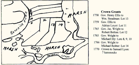
General Oglethorpe landed on the bluff of the Savannah River in 1733. His mission, as authorized by the King of England, was to establish a defense against the Spanish to the south in what is now Florida. He established a fort on the northeast end of Skidaway Island where Priest Landing Marina is now located. In 1758, Half Moon Village was established on the southwest end of the island, fronting on Skidaway River, now named Burnside River. The river was renamed for General Burnside, who was granted Rotten Possum Hammock, now known as Burnside Island. Crown grants were then given as shown on the map below. South Harbor derives from lots 11, 12, 13, and seven hammocks, also shown. These lots were 40 and 50 acres in size. In 1769 Michael Illy sold to Thomas Netherclift. In 1770 Samuel Lyon sold to Jonathan and Agnes Lightenstone. In 1773, the Netherclifts sold to Lightenstone. In 1774 Michael Reitter sold to Lightenstone. Robert Bolton sold to Samuel Lyon, who then also sold to Lightenstone. Then came the Revolutionary War. The Lightenstones were Loyalists and went back to England. Their property was confiscated March 1, 1778 by the Commissioner of Confiscated Estates.
Post Revolutionary War Period
In the Colonial Period, the original Half Moon Village Lots were consolidated into a single tract of approximately 400 acres by Netherclift, who sold to John and Agnes Lightenstone. The Lightenstones were loyalists and fled to England when the war ended. The land was confiscated by the State of Georgia in 1778. The land then went through many changes of ownership: Commissioners of Confiscated Estate to William O'Brien, the elder and Samuel Stirk, Esq. 1784. Then to Jas. Clay, Sr. 1793, then to Thomas Ward 1796, David Johnston to Nathaniel Adams, Planter, and his wife, Mary Ann in 1812. The Adams had a mortgage on the property which was foreclosed in 1817, and sold to A. N. Mayer, then to Serenus Meyer in 1828, then Mordecai Sheftall, Trustee for Mary C. Mayer in 1859. Then to Marmaduke D. Brown 9/15/1860. Marmaduke Brown was known as Captain Brown, as he served as a Hells Gate pilot to guide ships through the Skidaway Narrows. Until World War I, the narrows would be virtually devoid of water at dead low tide. It was dredged in World War I to make the Intracoastal Waterway, and deepened in WWII. Capt. Brown served in the Coast Rifles for Confederate Service and commanded a battery on Skidaway Island in the War Between the States. The Browns had three children. The older daughter, Rosa married Dr. Louis A. Falligant.
The Modern Era
In 1927, my father, Thomas W. Lufburrow, bought the land adjoining Union Camp, later the original Landings, extending from the Burnside River to Franklin Creek. During the depression, however, he had to sell, and he was heartbroken. Then in 1946, he, Jack Bryant and Judge Emanuel Lewis began to buy land on Skidaway and eventually owned from the Union Camp line to the southern marshes. In 1969, when the bridge was being built, my father’s two partners decided to sell. He asked if I wanted to sell, and I replied no. My father died in August, 1969. In January, 1970 the land was amicably divided, and our share was conveyed under my father’s will. We had much difficulty getting Green Island Road opened, although we had been given the right-of-way for it. It was finally cleared and opened as a dirt road in 1982. After I built our house, Curtis Lewis (who in the meantime had bought some of the land sold by my father’s two partners) and I were able to get the road paved by paying the cost of paving the section that passes through The Landings. On December 16, 1985, we signed the contract for the improvements for the first phase of South Harbor. And the rest is history, which you have helped make! South Harbor got underway in January, 1986, when Loyer Lane and Illy Court finally went on the market after years of hassle with Union Camp to deed the right-of-way for Green Island Road (then named McWhorter), more hassle with Chatham County to open and clear the road, and even more hassle with Union Camp to pay 1/3 of the paving. The bulkhead for the recreation area on the river and the structures at the entrance were constructed that same year.
Here is a chronological history of South Harbor’s growth and development in the following 18 years:
1987 - Lots on Lufburrow Way were platted. The boat hoist, fixed docks and floating docks were installed and 3.7 acres of river frontage were conveyed to the association.
1990 – The swimming pool was installed and additional land was conveyed.
1991 – The tennis court was built. 1992 - Lots on Rum Runners Alley were platted.
1993 - Ardsley Court and the first part of Netherclift Way were platted.
1994 and 1995 - The balance of Netherclift and Lightenstone Court was developed.
1998 - Bailey Reach lots were platted and Cactus Point Way was opened.
2000 - Samuel Lyon Way, Dr. Louis’ Way and Captain Brown’s Way were opened, and 5.5 acres of additional land were given to SHOPA so a clubhouse could be built.
2003 - More floating docks were added, and the boat yard was expanded.
2004 - Development of the final major phase got underway. Additional dock space was installed and donated to the Association including 600 feet of community space.